Historic Evansville
The definitive site for all things historic in Evansville
Historic Roads
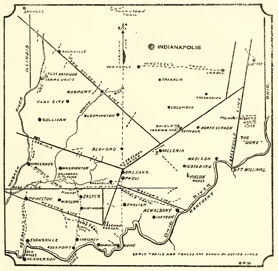
Southern Indiana Early Trails and Traces
Indian trails
Many led to Vincennes one of the oldest cities in the area. Another trail Yellow Banks red banks trace trail articlet 5/20/1928 to princeton vincennes to henderson high ridges 8/12/1965 ep - Red Banks Trace Mystery Unfolds red banks,ky (henderson) to vincennes territorial capital later state road * old state road * BNH - 1/4 w of Darmstadt Rd * st Joseph rd (ave?) - 1/4 mi south of Mill Rd * IN 66 - 100 e of mesker park dr [1965] * mesker park dr (100 ft south of Memorial Park) * red bank rd (intersection of broadway (white school) stage coach route state road contract to carry mail cut by buffalo then used by indians then by white settlers markers dedicated 8/20/1966 founders of cythiana took route claims overpass on 64 (st wendel-cynthiana rd) was part of trail??? starting from henderson running up the river to about Union-Perry Twp line, then north (west of evansville) princeton then vincennes yellow banks trail started from Ohio River at rockport and ran north (spencer) selvin yellow banks trace buffalo trace a really good source for indiana transportation history blog https://intransporthistory.home.blog/ https://ia800205.us.archive.org/27/items/earlyindianatrai63wils/earlyindianatrai63wils.pdf pg 23 and 54Country Roads
Country roads were established routes that connected to other nearby towns and communities. They were casually named after where the road led (i.e. New Harmony Road, Owensville Road) but later officially adopted the name. These county roads left Evansville like the spokes of a wheel headed in all directions. They followed along ridges and other natural features and are usually easily identified by their curvy routes.Along these roads, travelers would find stagecoach stops where they could board for the night and find a meal. Several of these building out in the county survived as taverns or restaurants which is why some of them still bear the name "inn" though they no longer offer overnight accommodations. Others, such as the Five Mile House, literally spelled out their distance from Evansville so travelers had an idea of how far to go before the days of GPS.
![]() See these routes on a current map [BETA].
See these routes on a current map [BETA].
| STREET | DETAILS
| State Road / Stringtown Road |
The original route into Evansville via Main St.
it was a state road because
Some older maps also label it as Vincennes State Road or Princeton Road because it followed north to the old capital of Indiana Territory.
Other towns along its route included Saundersville, Warrenton, Ft Branch? Haubstadt?
Before North Main was diverted it formed a straight line with stringtown Road
the segment from town to Stringtown. As the city grew the connection to Main St was chipped away and stringtown now
starts where garvin and governor split and Main St now diverts to the North Main.
for a time was plank road from columbia riverfront to pigeon creek. toll gate at poor farm at Columbia abandoned c1852 also built during civil war
had to cross the pigeon creek bottoms near negleys mill / stringtown bridge
Traces of the road connecting to Stringtown or Mechanicsburgh are now gone
It was part of the Dixie Bee Line Highway / US 41 when the thoroughfare was first established (ep 2/4/34+map)
van dusens mill
| Boonville Road / Newburgh Road |
Lincoln Ave east toward Newburgh and onward to Boonville [WARRICK CO]. The present-day Newburgh Rd splits off Lincoln just past Fielding Rd,
continues southeast merging with Covert Ave / IN 662, and eventually enters downtown Newburgh via Main St / Jennings St. Travelers would
then continue north on State St and then onto Old Plank Rd to get to Boonville. A northerly route to Boonville would be built later that
followed the canal / railroad (see below). |
New Harmony Road |
Northwest through Kasson, Parker's Settlement, Blairsville, Wadesville, and ultimately
New Harmony [POSEY CO]. The route originally started from Babytown and was later designated IN 66.
The segment from Harmony Way was bypassed c1936, and the highway was completely
rerouted in 1970, though the old New Harmony Rd still remains. |
Big Cynthiana Road |
Northwest from Kasson to the town of Cynthiana [POSEY CO]. It was later designated IN 65.
The road was later cut off when the Diamond Ave Bypass rerouted IN 66 |
Little Cynthiana Road |
Northwest from St Joseph Ave. The road passed by Mesker Park and was later renamed in its entirety Mesker Park Dr. It meets up
with Big Cynthiana Rd just north of Cynthia Heights and continues to the town of Cynthiana [POSEY CO] |
St. Joseph Road |
North then east from New Harmony Rd toward the community of St Joseph. |
St. Wendel Road |
Splits off Cynthiana Rd / IN 65 northwest to the community of St. Wendel. |
Owensville Road |
Northwest off Baseline Rd (near Hornville) to the town of Owensville [GIBSON CO] (hard time connecting) |
Upper Mt Vernon Road |
West (via a northerly route) toward the town of Mt. Vernon [POSEY CO]. Road starts from Franklin St / Mt Vernon Ave,
continues to St Philips, and merges with Blackford Rd / Tile Factory Rd into Mt. Vernon. |
Middle Mt Vernon Road |
West (via a central route) toward the town of Mt. Vernon [POSEY CO]. Road starts off Broadway Ave / Lower Mt Vernon Rd and
continues to Caborn [POSEY CO] but have a hard time connecting the entire way. |
Lower Mt Vernon Road |
West (via a southerly route) toward the town of Mt. Vernon [POSEY CO]. The road started from Howell and was later designated IN 62.
A more direct highway was built c1928, and Broadway Ave became the official route.
Where Old Mt Vernon Rd splits off is the original road which continues on until it reconnects with the main road just east of Mt.
Vernon. |
West Franklin Road |
South off Lower Mt Vernon Rd toward the river community of West Franklin [POSEY CO]. (Smith Diamond Rd renamed later?)
Another segment in Posey County with the same name heads south from IN 62 to the same destination. |
Green River Rd |
Riverside Dr turned into Green River Rd which headed southeast to where the Green River flowed into the Ohio River. This closely
aligned with E Riverside and some sections of Old Green River Rd are still in the river bottoms. When the present Green River Rd first appeared it
was New Green River Rd. Another map still shows Green River Road coming from a northerly direction see 1873 |
Boonville Highway |
As Evansville grew, a more northerly route to Boonville was sought. (virginia/oak hill?) The road left Evansville east from
Morgan Ave, continued to Theater Dr, and connected with the Old Boonville Highway as it headed to Chandler and then on to Boonville.
It was later designated IN 62 and would eventually be rerouted for a more direct route.
tied to railroad (1873)? built >1868 < 1876 (in atlas)
| Petersburg Road |
From Stringtown, northeast through McCutchanville,
Mackey, Oakland City, and on to Petersburg [PIKE CO]. It was cut off by the Evansville airport c1930 and
when IN 57 was built it bypassed most of the road within Vanderburgh Co.
| Darmstadt Road |
North beyond First Ave to the town of Darmstadt. |
Princeton Road |
Splits off Darmstadt Rd and continues through Haubstadt, Ft. Branch, and ends in Princeton (after traction line?)
| Boonville-New Harmony Road |
Traversed northern part of the county parallel to Evansville. The road dates back to 1820-1 and connected Boonville [WARRICK CO]
to New Harmony [POSEY CO] (trouble following west of St Wendel?). Purportedly went through Saundersville
| |
Originally the country roads were dirt pathways. One of first improvements were plank roads. Trails would get muddy and become impassable, so wooden planks were placed atop the road to help with traction. The result would be a smooth ride similar to a boardwalk. However, plank roads often did not wear well and required continual maintenance. Some had toll buildings along them that charged for passage. Later, many of these thoroughfares were also some of the first roads to get paved. They also had other improvements such as grading or slight reroutes (avoid sharp curves, changes to an intersection, etc). Over the years, most of the country roads are generally the same, but bypasses or newer highways have taken the traffic off some of them.
Section Line Roads
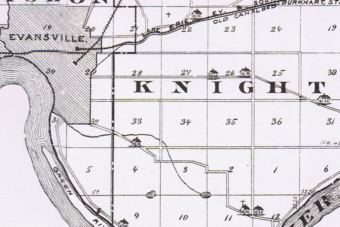
Numbered sections in Knight Township
from the 1876 Atlas
Section lines often doubled as property lines and were ideal locations to place roads. These roads were often named after the owner of the property at the corner or intersection where the road ended/began. Other times, major corridors in the Evansville area were simply extended as the city grew keeping the traditional grid layout. Regardless, these roads are easily identified because they run east-west or north-south on the section lines, and sometimes their midpoints.
Some examples include Washington Ave, Boeke Rd, Green River Rd, Burkhardt Rd, Pollack Ave, Vann Ave, Seminary Rd, Allen's Ln, Base Line Rd, Heppler Rd, Neu Rd just to name a few.
Auto Trails
With the popularity of the automobile in the early 1900s, auto trails were marked routes to help guide travelers. They were the forerunners of today's state highways connecting the dots between towns. Often times, auto trails had a badge or colored band that was posted on utility poles along the route. Guide books and sometimes newspaper articles would also spell out the directions "turn left" or "continue three miles."Auto clubs or other private organizations were formed to promote these roads. All of a sudden, there was a race to create faster and safer travel. While the auto trails help spur road improvements such as paving and more direct routes, they were truly designed for tourism and to bring visitors to the towns they passed through. In the same way railroads put towns on the map and being excluded could seal a town's fate, the same could be said of the roads.
Dixie Bee
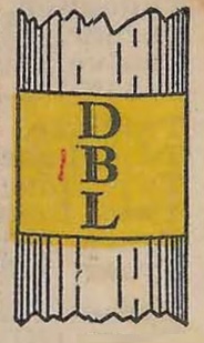
Dixie Bee Line badge
Letters "DBL" on yellow
| TOWN | ROUTE
| Henderson [KY] | Crosses into Union Twp via Henderson Ferry
| Evansville | Left town via Old State Rd
| *Warrenton | Followed US 41 / Main St
| Princeton | Followed IN 62
| *Patoka | Followed Old US 41
| *Hazelton |
| Vincennes | Followed Old US 41 / US 41
| *Oaktown | Followed US 41 / Business 41
| *Carlisle | Followed Old 41
| *Paxton | Followed Old 41 (later bypassed)
| *Sullivan | Followed US 41 (later bypassed)
| Terre Haute | Followed US 41
| Clinton
| *Newport
| *Cayuga
| Danville [IL] | joins with Dixie Highway
| |
![]() See the Dixie Bee Line on a current map [BETA].
+ Show research notes
See the Dixie Bee Line on a current map [BETA].
+ Show research notes
Market Highway / French Lick Rd
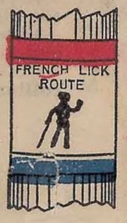
French Lick Route badge
red and blue
| TOWN | ROUTE
| Evansville | Left town off Dixie Bee / via Morgan Ave
| Boonville | Followed Old Boonville Highway
| Gentryville | Followed IN 62
| Huntingburg | Followed IN 62 to Dale and then US 231
| Jasper | Followed US 231
| French Lick | Followed ? IN 56
| West Baden | Followed IN 56
| Paoli | Followed US 150
| |
![]() See this route on a current map [BETA].
See this route on a current map [BETA].
The Loop
The Loop Road auto trail, often just called "The Loop," was a scenic route around the north side of Evansville that became popular when cars became mainstream. The leisurely 19-mile journey first shows up as far back as 1906 and references to it are found as late as 1936.The Loop left town north on Stringtown Rd cut across Campground Rd jogged at First Ave and returned via Kratzville Rd. to us41 / co infirmary? It passed notable landmarks Rose Hill Cemetery, Country Club, and Locust Hill Cemetery When the Princeton traction line was extended it also passed laubscher's station
![]() See this route on a current map [BETA].
+ Show research notes
See this route on a current map [BETA].
+ Show research notes
.jpg)
Hoosier Highway
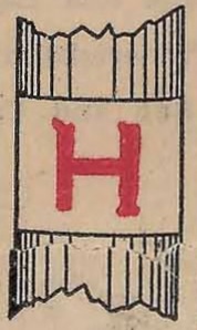
Hoosier Highway badge
Red "H" on white
| TOWN | ROUTE
| Henderson [KY] | Crosses into Union Twp via Henderson Ferry
| Evansville | Left town via Old State Rd
| *Warrenton | Followed US 41 / Main St
| Princeton | Followed IN 64
| Francisco | Roughly IN 64
| Oakland City | roughly IN 64 / IN 61
| Winslow | roughly IN 56
| Petersburg | Follows roughly IN 61
| Washington | OSR 28 OSR 4 OSR 12(IN54) switz city bloomfield
IN 57 / IN 67
| Worthington | Roughly follows US 231 / IN 67
| Spencer | Roughly follows US 231 / IN 67
| Martinsville | Roughly follows IN 67 / Kentucky Ave
| Indianapolis | Follows Massachusetts Ave / US-36 / IN 234 / IN 9
| Anderson | Follows IN 32
| Muncie | Roughly follows IN 3 / Hoosier Highway
| Bluffton | Follows IN 1
| Fort Wayne | Follows IN 37 / OH 2
| Bryan [OH] | Follows OH 2
| Adrian [MI] | Roughly follows US-127 / OH 66 / MI 52
| Ypsilanti [MI] | Roughly follows MI 52 / Macon Hwy / US-12
| Detroit [MI] | Follows US-12 / Business US-12
| |
There is still a small segment between Muncie and Bluffton still named Hoosier Highway today
![]() See this route on a current map [BETA].
See this route on a current map [BETA].
Kiwani's Trail (1922 / 1934)
Kiwanis auto trail to promote evansville landmarks and drive the town Kiwnanis Trail - vand co points (blue K on white) contest apr 1922, marked mid june 14 mi expanded by 1924 to 27 mi| TOWN | ROUTE
| Auto Club office | McCurdy Hotel (1st and locust)
| Riverside Dr | Sunset Park (right)
| Park Lane |
| Sunset Ave |
| Adams Ave |
| Riverside Ave |
| Howard St
| 2nd st
| madison ave
| linwood ave
| Ravenswood Dr
| Akin Dr
| Madison
| Kentucky Ave
| Washington
| Lombard
| Lincoln
| |
![]() See this route on a current map [BETA].
See this route on a current map [BETA].
Wonderland Way
stl to cincinnati maps only show new albany to corydon to paoli no maps show it coming through evansville but seems to approximate IN 62 ohio river scenic byway https://www.ohioriverbyway.com/Hemenway Highway
evansville to french lick hwy 16, hwy 18, and highway 40 c1924 through boonville, dale, huntingburg to french lick Named after james hemenway of boonville a good roads booster white bg with HH in blackState Routes
With the formation of the Indiana State Highway Commision, the state sought to establish some cohesion to roads across the area. Most were nicknamed https://www.fhwa.dot.gov/infrastructure/numbers.cfm FRom Names to Numbers - origins of the us numbered highway system. in depth on the issues with nicknames as well as many rules that defined a new numbering convention still used today 1917/9 ISHC formed 1-5 1919 formed 6-10 1923 given numbers 1-55 1926 great renumbering 10/1/1926 https://intransporthistory.home.blog/2019/04/30/the-great-renumbering/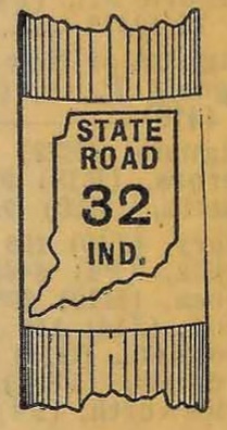 State Highway 10 - Evansville north Dixie Bee > Princeton, Hazelton, Vincennes, Terre Haute
State Highway 16 - Originally State Highway 4 Evansville to boonville (market highway) c1925 connection from Gentryville to Leavenwoth connected with the e
Route 16 enter at morgan ave (rear of oak hill cemter) and meet dixie bee at ross and morgan, ross to columbia, columbia to rose, rose to virginia, virginia to First, first to franklin, franklin to st joe, st joe to penn, penn to barker, barker to boradway to mt vernon
state road 16 = market highway to dale
becomes sr 62 mt vernon west to wabash river / IL was added 1929
State Highway 10 - Evansville north Dixie Bee > Princeton, Hazelton, Vincennes, Terre Haute
State Highway 16 - Originally State Highway 4 Evansville to boonville (market highway) c1925 connection from Gentryville to Leavenwoth connected with the e
Route 16 enter at morgan ave (rear of oak hill cemter) and meet dixie bee at ross and morgan, ross to columbia, columbia to rose, rose to virginia, virginia to First, first to franklin, franklin to st joe, st joe to penn, penn to barker, barker to boradway to mt vernon
state road 16 = market highway to dale
becomes sr 62 mt vernon west to wabash river / IL was added 1929
A renumbering in 1926 saw the adoption of north-south routes having odd numbers and east-west routes having even numbers. It was at this point most of the State Roads adopted the current numbers (see 10-28-23) https://www.in.gov/indot/resources/historic-maps/
-
Highway 69 (65 from 1926 to >1928) OSR 20 mv to nh to owensville (1923-26) poseyville and owensville
- Highway 62 - osr 16 renamed 1926 to 62 new albany to mt vernon / wabash river. passes through corydon leavenworth, st meinrad, lincoln city, gentryville, boonville and evansville (wonderland way? = yankeetown mt carmel to cynthiana poeyville aka newburgh rd (not lower)) (barker ave from penn to broadway in howell) 62 west? mt vernon to evv opened may 1 1928 paved broadway (pic ej 5/2/28) broadway (lower mt vernon rd) c1922 originall gentryville -> santa claus to st Meinrad would later skip santa clause and head through dale 1929
- Highway 66 (1926) - evv to rockport (newburgh, yankeetown, and hatfield) what about west section adopted 1930 20 mi to new harmony "new" aka harmony way?
- Highway 65 (<1930) - From Kasson to Cynthiana
- highway 57 (c1928) - "short route" to indy only built to about oakland City (paved to near elberfield) 1932, petersburg to wash planned 1932