Historic Evansville
The definitive site for all things historic in Evansville
Projects
|
Old State Road / Dixie B (1915) New Dixie B / US 41 (1923 / 1926 / 1932) Market Highway / Boonville Hwy / SR 62 (1923) Evansville-Mt Vernon Rd (c1928) Harmony Way (c1936) Fares Ave Bypass (c1936) West Side Expressway (1952-9) High St (1954) Columbia-Delaware Bridge (1956) Riverfront Boulevard / Southlane Dr (1963-8) Civic Center (1965) Airport / IN 57 (c1930) Airport Addition (1964) Diamond Ave Bypass (1969-70) I-64 (1968 / 1969 / 1971) US 41 Reroute (1972) Project B () Avondale () Lincoln-Governor () Bellemeade-Bayard Park () Grandview Towers () Diamond Ave (c1975) IN 62 Reroute (c1975) Ray Becker Parkway (1979) Lloyd Expressway (1984 - 1988) I-164 (1990) Airport Relocation (c2010) University Parkway (c2010) Fulton Interchange () |
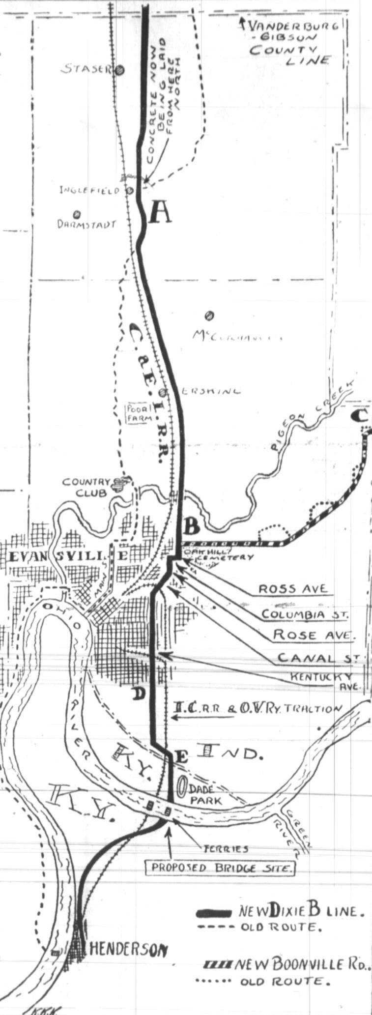
State Road / Dixie B (1915)
Old State Rd 10 osr Indian trail? In 1915 talk of a multi-state highway began to emerge. Local leaders, businessmen, and citizens began to petition to have the route via Evansville. The Dixie Higway stretched from Florida to Chicago but it passed from Nashville to Chicago via Louisville and Indianapolis. A more westerly and direct route was sought and the Dixie B (or Dixie Bee) was proposed. Multiple local Dixie B associations were formed to promote each town's interest in having the highway come through their city. On November 5, 1915, the Dixie B Route was decided. It capitalized on existing roads and roughly aligned with the old State Highway 10 (replace or diff route?). Even at that time, there was talk of an Ohio River Bridge but that wouldn't happen for several more years.| STREET | DETAILS
| Old State Rd | County line and on to Warrenton
| Stringtown Rd |
| Maxwell Ave | into Garvin Park
| Main St |
| Franklin St | down St Joe? Broadway? Barker? viaduct?
| Old Henderson Rd | ended at ferry
| |
New Dixie B / US 41 (1923 / 1926 / 1932)
|
| STREET | DETAILS
| US 41 | new road from Buslers north (bypasses Warrenton, Ft Branch and Haubstadt
| Old State Rd? | kept from intersection or retrouted later?
| US 41 | from Old State Rd to N Fares, new bridge
| Ross Ave (Willow) | routed to Fares c1936
| Columbia St
| Rose Ave (Fares)
| Canal St |
| Kentucky Ave | south to Ellis Park, ended at ferry
| |
+ Show research notes
Boonville Highway (1923)
Straigtened highway old boonville Rd [Feb 11 1923+map] tentative route| STREET | DETAILS
| Morgan Ave | Theater Dr was old road
| Old Boonville Hwy |
| Olmstead Rd | restaurant / connects to IN 62 [WARRICK CO]
| |
Evansville-Mt Vernon Road (c1928)
St Philip dedication broadway bypasses lower Mt Vernon RdHighway 57 (c1928)
IN 57 was billed as a more direct highway from Evansville to Indianapolis. The old SR 28 started in Winslow, connected to Petersburg, then Washington, and ended at IN 54 near Bloomfield). Evansville became the southern terminus and a new route? was built to Evansville bypassing the old Petersburg Road through McCuctchanville. It intersected with US 41 near the airport opposite Petersburg Rd. IN 57 officially opened Aug 28, 1928 with the dedication of new East Fork White River bridge at Rogers (northeast of Petersburg). The northern end was extended to IN-67 and the "short route" to Indy was complete.The highway would later be rerouted with airport addition in 1964. + Show research notes
Harmony Way (c1936)
Plans in early 1932 were looking at an improved route to New Harmony on IN 66. A new highway left Evansville north out St. Joseph Ave, curving near present day Diamond Ave. It continued in a fairly start line and connected with the existing New Harmony Rd just east of Kasson. Locally the entire new segment became New Harmony Rd and the older segment through West Heights adopted the name Harmony Way. Was the new addition harmony way? later swapped names? IN 66 Was segment in Posey County improved about the same time? The new route opened 8/12/36 Eventually becomes part of US460 / Diamond Ave and later is bypassed. + Show research notes| STREET | DETAILS
| St Joseph Ave / Diamond | * curved approach to St Joe (when?)
| Mesker Park Dr | * intersection mesker park dr (little cynthiana)Houses fronting road
| Allen's Ln | * intersection allens ln
| New Harmony Rd | Extends east toward Southern segment from Y now called Harmony Way
| |
Fares Ave Bypass (c1936)
Plans begun 1935 proposed to eliminate dangerous curve at Oak Hill Cemetery construction to begin 1936 Fares highway Morgan to US41 (old business 41) proposed to eliminate dangerous curve at Oak Hill Cemetery old leg to willow removed willow ends at diamond <1951 Expanded to 4 lanes from airport in 57 to 62 1940 A second pigeon creek bridge was added 1940 to make the highway 4 lanes can tell where it started where fares is wider north of MorganWest Side Expressway (1952-59)
A West Side expressway was a top priority of the Evansville Chamber to Commerce. The new thoroughfare would provide a fast route and help spur development on the West Side. When planning began in 1951 several routes were considered including Ohio St and Fraklin St. When the route was ultimately selected in 1952, Pennsylvania St was selected for the West Side Expressway which is why sometimes early on you see it termed Penn Expressway.Phase One

|
| STREET | DETAILS
| Second Ave | Start of expressway, intersection
| Third Ave | intersection?
| Goodsell St | intersection?
| Fourth Ave | intersection?
| Fulton Ave | intersection (later start of elevated section, converted to interchange c2010)
| Fifth Ave | ?
| Sixth Ave | ?
| Seventh Ave | ?
| Pigeon Creek | bridge
| RR | overpass
| Ninth Ave | Overpass
| Pennsylvania St | north sige removed exit at Wabash is old rd
| Wabash Ave | intersection
| Tenth Ave | intersection / south later disconnected
| Eleventh Ave | intersection later disconnected
| Twelfth Ave | intersection / disconnected to south later with MJ?
| St Joseph Ave | intersection
| |
Phase Two
The approximate two-smile stretch extended the West Side Expressway from St Joseph Ave to Red Bank Rd. Construction was begun in 1956 and the road opened July 1957.| STREET | DETAILS
| St Joseph Ave | Aligns with Pennsylvania St
| Bell St | dead end
| Lemcke Ave | aligned as intersection
| Pennsylvania St | North side (removed)
| Barker Ave | interchange
| Cobierre Ave | south side removed from Ingle to Barker, (including Addison, Leslie)
| Addison Ave | dead ends
| Ingle Ave | intersection
| Walker Ave | dead ends
| Tekoppel Ave | Overpass
| Dorothy Dr | (later closed)
| Rosenberger Ave | intersection (light later?)
| Red Bank Rd | intersection
| |
Phase Three
The final western corridor connected the expressway from Red Bank Rd to IN 62 near St Philip in Posey Co. It opened late 1959.| STREET | DETAILS
| Boehne Camp Rd | intersection
| Middle Mt Vernon Rd | intersection
| Felstead Rd | intersection, extended to hwy?
| Schutte Rd | Intersection
| Mahrenholz Ave | split
| McDowell Rd | intersection
| Posey County Line Rd | Intersection realigned to intersect at right angles
| St Phillips Rd [POSEY CO] | cuts off old Broadway
| |
High St (1954)
high st 1954 riverside fulton, carpenter bond market clark urban renewalColumbia-Delaware Bridge (1956)
columbia-delaware bridge dedicatted 3/21/1956 http://local.evpl.org/views/viewimage.asp?ID=924366Riverfront Boulevard (1963-68)
sought 59 and planned 1960 riverfront boulevard/us 41-a extended to us41 southlane drive levee rework? riverside Ingle St to mulberry 63 demolish waterworks garage end Ingle at 1st ingle st wareshouse tracks pulled up lawsuit mar 64 opened to traffic jul 10 1064Phase 3
also segment from court to west side expy opened earvly nov 67 constr planned to start 65-7 Sunset Park (mulberry) to US 41 two mile extension corner demolished Park Place / Sunset (cook house) instersects sunset Ave / Shawnee Dr southlane dr opens 12/13/68 ribbon cutting by santa clause veterans memorial c1985Civic Center (1965)
civic centerAirport /hw57
along dixie b hwy split off old petersburg rd? rerouted? c1930 1941 bypass >1938 <1946 1937 plans "short route"Airport Relocation (64)
airport relocation 1964 Dress Memorial Airport enlarged to handle commercial jets rerouted roads ne-sw http://local.evpl.org/views/viewimage.asp?ID=787747| STREET | DETAILS
| Oak Hill Rd | Moved?
| Whetstone Rd | Segment closed, two dead ends
| Ward Rd |
| Rucker Rd | Closed
| RR | Rerouted south and west
| IN 57 | Rerouted slightly to the north
| Millersburgh Rd | Closed west of Oak Hill
| |
Diamond Ave Bypass (1969-70)
diamond ave 460w of 41 morgan ave 460e of 41 in 62 east of evansville, in 66 west of evansville. replaced by i64 and Bypass around kasson 1969-70 to eliminate the curvy New Harmony Rd. Connects Diamond Ave IN 66 with Posey County near Parker's Settlement| STREET | DETAILS
| IN-66 [POSEY] | Road splits east of Parker's Settlement
| New Harmony Rd [POSEY] | Western end dead end (Old New Harmony Rd) | Road curves north to intersect with highway (Old IN-66) Vienna Rd | Ts with highway, no longer connects to New Harmony Rd
| St Joseph Rd | Intersection
| Mill Rd | Split, St Joseph Rd dead end eastern section curved south toward highway
| Happe Rd | Intersection
| Big Cynthiana Rd | Split by highway two dead ends, replaced by Resurrection Dr, reworked toward IN 65 near Kasson School
| Detroy Rd | intersection
| Allen's Ln | split by highway two dead ends
| New Harmony Rd | Eastern end Y with highway
| |
I-64 (1968 / 1969 / 1971)
The idea was first discussed in 1956 with the passage of interstate system. As the "Crossroads of America," Indiana had its share of interstates but most went through Indianapolis. I-64 was proposed to traverse the southern part of the state connecting St Louis, Mo. to Louisville, Ky. but the exact route was up for debate. Orignally it was planned to follow close to US 50 closer to Vincennes, however officials settled on northern Vanderburgh Co. after a push for the interstate to come closer to Evansville.The entire I-64 would take several years to complete, and it was built in phases cutting accross undeveloped areas. Construction began near the Illinois border continuing eastward and sections near New Albany progressed to the west until they met in the middle.
Phase 1
The first portion of I-64 built in Vanderburgh Co. connected IL 1 just west of the state line to IN 65. Construction on the 18.5 mile section started in 1966. A ribbon cutting on Aug 1, 1968 marked its opening and with the road crossing state lines it was truly an "interstate."| STREET | DETAILS
| IL-1 |
| Wabash River [STATE LINE] | bridge
| IN-69 | interchange (New Harmony / Mt Vernon / Griffin)
| IN-165 | interchange (Poseyville)
| IN-68 | underpass
| IN-65 | interchange (Cynthiana / Evansville), Scott Rd rerouted connects to Water Tank Rd [POSEY CO]
| |
Phase 2
The second section built in the area was an 8.2 mile span that connected IN 65 to US 41. A frontage road to the south where traffic was cut off by the interstate. A ceremony was held Oct 1, 1969 on the Wabash River bridge on the Indiana-Illinois border to mark its opening.| STREET | DETAILS
| IN-65 | interchange (Cynthiana / Evansville)
| Scott Rd | rerouted for interchange, connects to Water Tank Rd [POSEY CO]
| Pruitt Rd | disconnected from County Line Rd, connects with Frontage Rd
| Bixler Rd | disconnected from County Line Rd, connects with Frontage Rd
| Montgomery Rd | disconnected from County Line Rd, connects with Frontage Rd
| Owensville Rd | underpass, connects with Frontage Rd
| St. Joseph Ave | disconnected from County Line Rd, connects with Frontage Rd
| Princeton Rd | underpass, connects with Frontage Rd
| US-41 | interchange (Evansville / Terre Haute)
| |
Phase 3
The next segment was a 4.3 mile stretch that connected US 41 to IN 57. Construction started April 1970, and the section opened Sept 3, 1971.| STREET | DETAILS
| US-41 | interchange (Evansville / Terre Haute)
| Old State Rd | underpass
| Barton Rd [GIBSON CO] | underpass
| IN-57 [GIBSON CO] | interchange
| |
![]() See this project on a current map.
See this project on a current map.
US 41 Reroute (1972)
As the automobile established dominance, many US highways the used to connect the heart of the town sought bypasses. reroute four lane giblert harlan-corridor proposed 1948-9 improvements in other roads left route in question willow south curve west toward harlan swing west to kerth back to harlan and out past leveeConstruction was scheduled to start 1965-7. The 6.23 mi route would extend from Southlane Dr to just north of Pigeon Creek 10/15/66 to start buying land franklin and south construction near nov 1969 Construction continued into 1971 with an estimated completion of summer 1972. In Summer 1972 the northern portion from Virginia St to Pigeon Creek opened, and later in the summer from Southlane Dr south to the levee where it connected to the existing US 41.
The new US 41 formally opened after a dedication ceremony on Nov 30, 1972. The design was "25 years out of date when they cut the ribbon" and helped Evansville earn the nickname "Stoplight City." The old 41 would become known as Business 41.
Project B (1975)
project b renewal area 1975 mulberry,8th,4th chandler urban renewalAvondale (1975)
avondale urban renewal 1975 urban renewal pigeon creek diamond colorado first seven blocksLincoln Governor
lincoln ave-governor urban renewalBellemeade Bayard Park
urban renewal bellemeade-bayard parkGrandview towers (1978)
grandview towers 1978 diamond valley elderly apartmentsDiamond Ave (c1975)
us 460 west of st joe and extended to heidelbach-60 ft completed by 1963 heidelbach ext c1963 urged to continue e to booneville hwy or green or i164 later planned heidelbach to 41 1964 completed by 1968 connected to weinbach 1975 in 1951 ends just west of heidelbach east at weinbach| STREET | DETAILS
| St Joseph Ave / Diamond | turned into intersection
| Grove St | * overpass grove st
| Kratzville Rd / 5th Ave | * intersection kratzville rd/5th ave (fulton)
| First Ave | intersection. demo most of Avondale?
| Pigeon Creek | * pigeon creek to original diamond ave
| |
IN 62 Reroute (c1975)
IN 62 used to travel down Barker Ave to Howell and continued west on Broadway out past the county line. The old 1930s highway was a curvy two-lane country road. A new 4-lane highway was built harnessing some of the existing West Side Expressway. The new highway cut diagonally through Perry Township and met with the old route near St Phillips Rd. IN 62 was made a 4-lane divided highway all the way to Mt Vernon.| STREET | DETAILS
| Red Bank Rd | Previous end of West Side Expressway. The existing section near Rosenberger Ave westward was converted into a divided highway.
| Boehne Camp Rd | Intersection
| Middle Mt Vernon Rd | Intersection, realigned to be square to highway
| Felstead Rd | Ends at highway, used to end at Middle Mt Vernon Rd
| Schutte Rd | Intersection
| Mahrenholz Ave | Subdivision road now cut off by highway
| Eichoff Rd | Now ends at highway, used to extend south
| McDowell Rd | Intersection, slightly realigned to be square to highway
| Posey County Line Rd | Intersection, realigned to be square to highway
| St Phillips Rd [POSEY] | Intersection just north of old highway, road to south becomes West Franklin Rd
| Old IN 62 [POSEY] | Old highway merges into new construction near Heusler Inn.
| |
River Parkway / Ray Becker Parkway (1979)
Residents on the West Side knew well that a train could completely mess up travel time. Drivers would have to cross tracks on St Joe just south of Mead Johnson and would then re-cross on Broadway Ave at the 7-crossings to get to Howell. As far back as the 1920s, there was a desire to bypass this area the and improve travel to points farther southwest.In the early 1970s, the River Parkway project was given priority. It would bypass the Howell railroad tracks and provide a quick route especially for emergency vehicles which were at the mercy of a stopped train. During planning, one idea was a Barker Ave Underpass which was never realized. By early 1974, the 3/4 mile route between Ohio St and Barker Ave was chosen. When the design ended up cutting in the base of Reitz Hill, a deal was negotiated to swap for the training lot adjoining Howell Park. The parkway was renamed in March 1975 after the late Ray Becker, a city councilman who was a proponent of the project.
Ground breaking for the Ray Becker Parkway began October 29, 1975. There were delays and the 2-year project dragged on. Mead Johnson demanded access to their parking lot that was now cut off from Ohio St so the city agreed to build an underpass in summer of 1976. A mudslide at foot of Reitz Hill in December 1978 cost $940,000 to repair, which is why there is a large section of rip rap (rocks) at the bottom of the hill. The road finally opened October 26, 1979. As a final insult, a delay in acquiring the stop lights caused several accidents until they were installed.
| STREET | DETAILS
| St Joseph Ave | connects near Ohio St, RR tracks rerouted, Broadway Ave disconnected
| Claremont Ave | intersection (stoplight)
| Barker Ave | western end (stoplight), A St removed
| Broadway Ave | Closed at RR, connects with Dixie Flyer Rd
| Dixie Flyer Rd / River Road | Expanded and connects Broadway Ave to Old Henderson Rd
| |
Lloyd Expressway (1984-1988)
Division St Expressway Continuation of West Side Expressway (phases 1-3) state and federal approval in 64-5 but expired when they failed to meet requirements of federal highway renewed in earnest 1979 Renamed Russel G Lloyd Memorial Expressway after the mayor slain in 1980 For the most part, Division St to the north becomes westbound access road and John St to the south is the eastbound access road. construction began may 1984. The initial work consisted of clearing buildings and building the elevated sections. Before the expressway officially opened the access roads handled trafficphase four.1 - east to harlan

|
3rd/5th/first configuration into and out of downtown summer 86 opened to First (0.3 mi) aug 21 1986. eastbound exit at Market St (now gone) and exit to First Ave further opened to main dec 19 86. eastbound had to exit at Main. westbound open from mary/7th onramp (now closed) access lanes connect to us 41 jun 87 but not on primary road southboudn onramp to 41 open open to 41 oct 2 1987 initial speed limit of 40 had people angry with delay dec 29 87 vann to green opens but exits onto green while overpass is finished east of green both directions share the north (westbound) segment to burkhardt us41 to vann opens fri jun 24 1988 but one lane and some overpasses closed Delayed years target fall 88 eventually to green river c1988 connecting i164 by sept 1988 41 to vann oct 87 billed each day late opens july 19 1988 from fulton to 1/2 mi past burkhardt (ep 7/9/88) elevated highway starting at Fulton light ohio = RR Market/3rd/5th/4th alignment parkliike intrance into out of downtown
| STREET | DETAILS
| Fulton Ave | intersection w/ stoplight (later converted to full interchange)
| Fourth Ave | *crosses penn (to ohio) > cut off, dead ends past indiana (n) and ? (s)
| Goodsell St | *crosses penn (to ohio) > cut off, dead ends past indiana (n) does not connect to access rd and ends at new John st / access rd(s)
| Third Ave | *crosses penn (to ohio) > cut off, dead ends past indiana (n) and dead ends past ohio (s) neither road connects to access road
| Clark St | ends at penn (to ohio) > cut off, mostly gone?
| Second Ave / Market St/3rd | * > 3rd/market realigned with overpass
| First Ave | 3rd St 4th St overpass turned into a complex exit for one-way traffic into and out of downtown
| Ohio St | *crosses 3rd/market, 4th, ends at 5th & penn (wedge) > tracks still there but road ends past third before curve
| 5th St | *crosses bond, ends at ohio & penn (wedge) > cut off, ends at bond
| Oakley St | *ends at penn > NC
| 6th St | *crosses ingle, crosses bond takes funny angle toward oakley, ends at penn > cut off, dead ends past ingle
| Bond St | *crosses 5th, 6th, ends at penn (opposite edgar) > cut off, ends at 5th
| Edgar St | *ends at penn (opposite bond) > ends at franklin (berry?)
| 7th St | *crosses court, ingle, ends at penn > overpass curves at John to align with 7th overpass
| Mary St | *ends at penn > NC now aligns with 7th overpass
| 8th St | *crosses court, ingle, ends at penn (wedge) > dead ends pass court
| Harriet St | *ends at penn > NC
| Ingle St | *crosses 7th , 8th, ends at penn (wedge) > dead ends past 6th (turnaround)
| Read St | *ends at penn (opposite 9th) > NC
| 9th St | *ends at penn (opposite read) > ends at court
| Garfield St | *ends at penn > NC
| 10th St | *crosses vine, ends at court > ends at vine
| Court St | *9th, 10th, ends at penn > cut off, ends at 9th segment between div and baker remains
| Baker Ave | *ends at penn > NC
| Vine St | *crosses penn, ends at main (wedge) south to 10th > leg cut off curves from John and Main to downtown
| Main St | overpass
| Elsas Ave | *crosses div and john > cut off, ends at franklin (vectren?) n and john (s)
| Heidelbach Ave | *crosses div and john > overpass
| Lafayette Ave | *crosses div and john > cut off, ends at division (n) and john(s)
| Governor St | *crosses div and john > overpass
| Elliott St | *crosses div and john > cut off ends at indiana (?) (n) and John (s)
| Garvin St | *crosses div and john > overpass
| Sherman St | *ends at division > gone? ends at RR (?)
| Morton Ave | *jogs at div crosses john > cut off, ends at John (s) and Division (n)
| Linwood Ave | *ends at division > gone?
| Denby Ave | *ends at divsion (opposite crown pottery) > cut off, dead ends past John
| Bedford Ave | *ends at divsion > cut off, dead ends past Canal
| Grand Ave | *ends at RR / Canal > no change
| Canal St / Kentucky Ave | south side canal curves to s kentucky, north side division shifted north
| New York Ave | *ends at divsion > ends at sycamore
| Kerth Ave | *jogs at div > ends at sycamore see 41 interchange
| us-41 | interchange underpass with stoplights on lloyd exits
| Fares Ave | *jogs at div >
| Lewis Ave | *ends at divsion >
| Harlan Ave | *jogs at div >
| |
phase four.2 - harlan to boeke
| STREET | DETAILS
| Willow Rd |
| Bennighof Ave |
| Englewood Ave |
| Runnymeade Ave |
| Rotherwood Ave |
| Oakland Ave |
| Norman Ave |
| Frederick St |
| Weinbach Ave | interchange
| Lincoln Park Dr |
| Spring St |
| Kelsey Ave |
| Alvord Blvd | overhead walking bridge for Harper School
| Fairlawn Ave |
| Parker Dr |
| Taft Ave |
| Boeke Rd | interchange
| |
phase four.3 - boeke to green river
| STREET | DETAILS
| Harper Ave |
| St James Blvd |
| Ruston Ave |
| Villa Dr |
| Thomas Ave |
| Dexter Ave |
| Welworth Ave |
| Vann Ave | intersection
| Stockwell | intersection
| Congress Ave |
| Iriquois? |
| Kenmore? |
| Euclid? |
| Polster? |
| Harrison? |
| Green River Rd | intersection
| |
pennsylvania-division st expressway
rerouted tracks nw
north side bypass opened aug 1973
plans 1978
interchange at US41
when was it extended out to county line / i164?
aug 87 plans to extend from green
put lights at fielding (harrison) and burkhardt
planners wanted frontage roads but existing development and not enough right of way made it impractical
+ Show research notes
I-164 (1990)
I-164, a spur of I-64, had been in the works for some time. Even as far back as 1964, a Circum-Urban was recommended to connect Evansville with the interstate that was routed way north of town. During the planning phase, western and central branches were proposed but eventually the eastern branch was selected. I-164 was initiallly planned to end at Division St or Newburgh Rd, but it was ultimately decided to connect all the way to Southlane Dr / US 41The interstate, a roughly 20 mile stretch from US 41 along the east side of the county to I-64, opened Aug 1990.
| STREET | DETAILS
| US 41 | Interchange
| Weinbach Ave | Overpass
| Covert Ave / IN 662 [WARRICK] | Covert Ave Extension connects from Green River Rd to new interstate. Covert Ave and Newburgh Rd form intersection with exit ramps
| Lincoln Ave [WARRICK] | Overpass
| Lloyd Expressway / IN 66 | Interchange
| Oak Grove Rd | Overpass
| Morgan Ave / IN 62 | Interchange
| Old Boonville Hwy | Underpass
| Lynch Rd | Interchange (2007), lynch rd extended?
| Olmstead / Burkhardt | Overpass
| Heckel? | ? to co line? now dead end
| Miillersburgh Rd | Overpass
| Kansas Rd | dead end
| Boonville-New Harmony Rd | Interchange partially realigned. Old segment on east portion. county line rd realigned too?
| IN 57 | Interchange complex interchange, IN 57 realigned (old hwy 57)
| Seven Hills Rd | now dead end
| Elberfeld Rd | Overpass
| I-64 [GIBSON] | Interchange Later extended north as part of I-69 (opened sept 2009)
| |
The spur was renamed I-69 in 2014 as part of a larger Canada to Mexico interstate project with segments still to be completed.
A new bridge over the Ohio River was planned in 2022 east of the existing twin bridges connecting on the south side of Henderson.
+ Show research notes
Airport Relocation (c2010)
| STREET | DETAILS
| Millersburgh Rd | Western end now curves north to roundabout with Oak Hill Rd
| Oak Hill Rd | Closed at IN 57, Southern section now curves east to roundabout with Millersburgh Rd, continues north to Kansas Rd roundabout
| Hedden Rd | ?
| |
University Parkway (c2010)
university school north found as far back as 1969 desire to make a western corridor proposed as IN65 http://local.evpl.org/views/viewimage.asp?ID=877925Phase 1
| STREET | DETAILS
| Middle Mt Vernon Rd / Eickoff Rd | * reroute middle mt vernon intersection of eickhoff, bockelman school moved
| Hogue Rd | intersection
| RR | overpass
| Upper Mt Vernon Rd | end of Expressway for years.
Wolf School demolished
| |
Phase 2
| STREET | DETAILS
| Marx Rd |
| New Harmony Rd |
| unnamed drive | intersection
| Diamond Ave / IN 66 | Ts
| |